


Basics
- Location:
- Located in the Mountain Heritage and Rangeley Lakes area of Maine
- Length:
- 35.6 miles (57 km)
- Time:
- 2.5 hours to drive and 8 or more hours to visit this Byway
- Season:
- Year round
- Fees:
- There are no fees.
Description
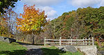
Beginning its twisted journey at Smalls Falls on Route 4, Rangeley Lakes Scenic Byway meanders past mountains, lakes, and rivers. Smug with pride, the little village of Rangeley sits within a picturesque panorama.
Beginning at Smalls Falls on Route 4, the Byway heads northward to the intersection of Route 17, then loops southward to the Height of Land.
The Byway wiggles past Rangeley Lake and takes Route 17 to the Height of Land. Southward bound, it runs past canyons and streams that give way to expansive farmlands. Its route covers over 33,000 acres of public conservation land.
Throughout the year, visitors come to enjoy a treasure trove of recreational activities. From fishing and hiking to snowmobiling and canoeing the Swift River, this route is bespeckled with things to see and do. Leaf peeking, hiking, biking, nature watching, boating, fishing - it's all here. And between apple festivals, summer concerts, and the crispy celebration of the winter holidays, Rangeley treats its guests with a titillating display of warmth.
Tourism Resources
Helpful Links
Tourism Resources
Points of Interest
Points of Interest Along The Way
Appalachian Trail (ME)
Eighty years ago, Benton MacKaye dreamed of a footpath runningalong the eastern mountains. The dream became a reality in the formof the Appalachian Trail which extends more than 2,160 miles fromMaine to Georgia. The section of the trail between central Maineand western New Hampshire offers some of the most rough andchallenging terrain coupled with some of the harshest weatherconditions of the entire Appalachian Trail. Some people have hikedor walked the entire Appalachian trail -- a feat that can take fromsix to eight months. Visitors to the Rangeley Lakes Byway may wishto just take a day trip.
One area of heavy use near the Byway is Saddleback, from theHorn to SR 4. Hikers may wish to try other sections as well. Thetrail crosses both SRs 4 and 17 and provides recreational access tothe extensive trail system and many of the highest peaks in thearea. The Route 17 crossing is at Height of Land with panoramicviews of the White Mountains and Rangeley area. The Route 4crossing is very near Piazza Rock, an enormous, flat, overhangingledge slab that supports mature trees. Piazza Rock and severalboulder caves are accessed via a clearly marked side trail from theAppalachian Trail. Hikers should keep their eyes open for moose,which are common, but remain at a safe distance.
Directions
The trail bisects both SRs 4 and 17 at an inverse angle to the road (see map).
Height of Land (ME)
Height of Land is one of the most stunning and unsurpassedoutlooks in the state of Maine and offers the traveler beautifulpanoramic westerly views of hundreds of square miles of pristinelakes, majestic mountains and lush forests that dazzle viewers inthe autumn with rich shades of red, orange, and yellow. Enjoy thebeautiful views of the clear blue Mooselookmeguntic Lake, as wellas the spectacular White Mountain chain in neighboring NewHampshire. Height of Land has been considered by some to even offerthe most spectacular overlook in all of northern New England. TheAppalachain Trail crosses Route 17 immediately adjacent to thisturnout.
Directions
It is just a couple of miles north of Byron on SR 17.
Madrid (ME)
Madrid is a small community in western Maine. A small population helps keep Madrid in touch with its history.
Mooselookmeguntic Lake (ME)
The name Mooselookmeguntic is said to have originated from anancient Abanaki word. It means portage to the moose feedingplace, or moose feeding among the trees. This lakeis 16,300 acres in size, the second largest in Maine, and is famousfor its recreation opportunities and magnificent scenery.
Mooselookmeguntic Lake is full of salmon, brook trout fallfish,brown trout and many other types of fish, bringing fisherman fromall areas to the lake.
Hiking trails around the area also provide campers and day-trippers with beautiful views of the area. Just three miles fromRockery campground on the Mooselookmeguntic Lake is the AppalachianTrail, which provides a route to the Height of Land Overlook, whichoffers a spectacular view of the lake and surrounding areas.
The land surrounding Mooselookmeguntic Lake boasts 9 majorprotected land parcels. These parcels are public access and can beused for recreation such as camping, walking and hiking the trails,and wildlife viewing.
Directions
Access is through the town of Oquossoc on Carry Road to Haines Landing.
Rangeley Historical Society (ME)
The Rangeley Historical Society's museum, a non-profit and educational museum has an extensive archive of artifacts, records, and photographs that cover the people and popular activities of Rangeley's past and present. The collection is housed in a classical revival style building built around 1905. The society has a complete collection of vintage hunting and fishing equipment and historical photographs and is open to visitors in July and August only.
Directions
It's in the center of Rangeley village.
Rangeley Lake State Park (ME)
This park is reknowned for its large, private campsites, its trails, its beach and launching area as well as the access it provides to recreation.
Rangeley Lakes Region Logging Museum (ME)
This region is almost entirely forest and has an extensive history in pulp and paper production. The Rangeley Lakes Region Logging Museum consists of a three-story building on 18 acres of land. The museum displays collections of hundreds of artifacts from regional logging operations, including snubbing machines, sleds, and an extensive collection of crosscut and chain saws.
The museum also sponsors the Logging Festival Days in Rangeley on the last Friday and Saturday in July. Activities include the Burying of the Beans -- logging "camp style"; music, entertainment, and a Logger's Hall of Fame; and a parade of floats, bands, and logging equipment. The festivities continue with woodsmen's competitions of chain sawing, pulp piling, axe throwing, and more.
Directions
It's in Rangeley city.
Rangeley Overlook (ME)
This lakeside overlook provides a 180 degree view of Rangeley Lake, Saddleback Mountain, and Mooselookmeguntic Lake.
Smalls Falls (ME)
Smalls Falls sits just south of Rangeley, and it serves as the beginning point for the Rangeley Lakes Scenic Byway. A popular place to picnic, it provides picnic tables and fire pits. Many who come here don’t just picnic; they play in the pools created by the 54-foot waterfall. Hike the short path to the top of the falls in 5 minutes. The gorge walls, colored in green, gold, and orange, are perfect places to perch and admire the scenery.
Swift River (ME)
The Swift River is one of the most protected in the state of Maine. This is because of its outstanding scenic, natural, and recreational qualities. The Swift River runs through a magnificent hardwood forest that is beautiful during all timees of year, but is known for its brilliant autumn folliage. The Swift River can be canoed from Byron, at the Route 17 bridge, to Mexico; mostly class I -III rapids. It's best if run by expert canoeists at medium water.
Directions
Follow ME-17 south to Byron. The river is on the west side of the Byway.

