


Basics
- Length:
- 12.5 miles (20 km)
- Time:
- 30 minutes without stops
Description
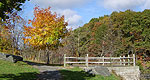
The Blacks Woods Byway is located in the Washington and Hancock Counties of Maine. It runs parallel to Route 1, trekking through postcard views of blueberry barrens, bare mountains and granite coastline. And, it never loses its unspoiled New England character throughout its journey.
This Byway starts in Cherryfield and follows Route 182 to Franklin in Washington and Hancock County in the "Downeast" section of Maine.
There are numerous historical and scenic stops en route. And, the traveler is afforded ample opportunities for hiking the nature trails that wind their way around countless lakes and ponds in the area. Snapping pictures of the scenic views of Cherryfield and Tunk Lake, among others, is a pleasurable sport, as well.
Points of Interest
Points of Interest Along The Way
Black Mountain (ME)
Black Mountain is known as Bald Mountain to the locals. It stands at 1,094 feet and can be approached from the byway through public reserve land trails off of the Dynamite Brook Road.
You can climb it from the shore, provided you have a boat. Now, the mountain's trails are marked, so visitors may navigate any variety of peaks, taking hikes that can last anywhere from couple of hours to a full, exhausting day.
When the skies are free of clouds and the day is clear, Black Mountain's top rewards hikers with tremendous views of surrounding lakes and the coastline of Mount Desert Island to Cutler.
A long, sandy beach sits at the base of the mountain, creating a 1.7 mile trip by canoe, kayak, or other modest watercraft. Nearby, Wizard Pond is a mystical destination that rests between Black Mountain's twin peaks, and Rainbow Peak can be reached from Black Mountain's rough trails.
Directions
From the byway, go to Dynamite Brook Road and follow public reserve land trails.
Catherine's Mountain (ME)
Catherine's Mountain, known locally as Catherine's Hill, stands at 960 feet. The byway climbs from Fox Pond to Catherine Mountain's north shoulder, and at the crest of the road, an open meadow awaits. Here, you can park and hike the steep, mile-long trail to the mountaintop. On the way, you'll cross small pit mines from the 1800s. In August, you can pick wild blueberries near the top.
Cherryfield (ME)
Cherryfield, known as the "Blueberry Capital of the World," cultivated approximately 3 million pounds of blueberries in 2001, and around 7,000 acres in this town are under blueberry cultivation. This historic town, located on the eastern end of the byway, carries a rich, well-preserved history in fishing, lumbering, and blueberrying. The land is filled with fields and farms, and it has a designated historic district with more than 40 houses that are listed on the National Register of Historic Places. Some homes date back over 200 years.
Cherryfield holds many traditions that have lasted for more than a century. One popular tradition takes place during the weekend prior to July 4th, when Cherryfield hosts a celebration filled with musical performances, a parade, and the annual "bed race" in which contestants race down Main Street pushing a variety of beds on wheels.
Donnell Pond (ME)
Donnell Pond covers about 1,000 acres, and it has become a popular recreation site for locals. Much of the shoreline remains publicly owned, but campsites have been established in the southern half. Please note that there is no road access to the campsites, but you can cross the pond by canoe or small motorboat to camp. You could also reach the campsites from Route 183 from Route 1 in Sullivan and use the parking facility available.
Directions
Enter from Route 183 from Route 1 in Sullivan to access the campsites at Donnell Pond.
Dynamite Brook Road (ME)
Dynamite Brook Road is on the south side of Catherine's Mountain, at mile 4.3. It provides a glimpse into the 1800s when blasting was a popular method used to search for gold and silver on the slopes of Catherine's and Caribou Mountains. On the south side of the road, old mining pits can be seen. Geologists, mineralogists, and rock collectors love to stop here.
The road is also great for hiking. You can walk to Donnell Pond from the end of Dynamite Brook Road in about an hour. If you want to continue around the east side of Donnell Pond, you'll reach a swimming beach within another 20 minutes, or climb the summits of Black or Schoodic Mountain in a couple hours of challenging climbing. During late July to mid-August, wild blueberries ripen on mountaintops and ledges.
Directions
Dynamite Brook Road is south of the byway at mile 4.3.
Fox Pond (ME)
Fox Pond covers 64 acres of water, and it is bordered by rocky shores on the east side and a boggy habitat to the west. Here, you'll find some of the most entertaining water recreation along Blackwoods Byway. On one end, a rope swing dangles above the water, coaxing the daring to launch into the water. There are also places to hand-launch canoes, kayaks, or rowboats for paddling and fishing.
Franklin (ME)
Franklin sits on the western end of the Blackwoods Byway. Here, much of the land is devoted to the production of blueberries and wood. The historic town center is a crossroads for SR-182 (Blackwoods Byway), SR-200, and the Calais Branch Railroad.
Franklin follows a long section of the shoreline on Hog Bay, which drains through Taunton Bay to the Atlantic Ocean. Blackwoods Byway offers wide views of the Bay, and at low tide, you might see people slogging in the mud with short-handled rakes digging for fishing worms and clams.
Schoodic Mountain (ME)
Schoodic Mountain reaches nearly 1,080 feet and is a classic glacial mountain with varied gradual and plunging slopes. It features several popular hiking trails that link it to Donnell Pond, Tunk Lake, and a sequence of eastern mountains.
Climbers will enjoy the panoramic view from the top of Schoodic Mountain. It looks down on Acadia National park to the south, the Downeast region to the north and the east, and a vast sparsely populated woodland region to the north and west. A dirt road called General Cobb Lane in East Franklin on SR-200 or SR-183 in Sullivan both serve as popular starting points for mountain climbers.
Directions
Either take Route 200 in east Franklin to a dirt road called General Cobb Lane or take Route 183 in Sullivan.
Spring River Lake (ME)
Spring River Lake stretches for two miles, and contains a conglomeration of public areas, private camps, and undeveloped shoreline. Fishing, swimming, and boating are all popular activities. Hunters love the uplands during November.
Township 10 (ME)
Some of the most exciting sections of the Blackwoods Byway pass through Township 10. Nearly 8 miles of the route run through the heart of a forested landscape, twisting and turning, dodging hills, rock outcroppings, and bogs. At mile 2.7, a dirt road heads north and connects you to more than 700 miles of gravel roads that are available for off-road, shared use, including mountain biking and all-terrain vehicles (ATVs). Ambitious trail riders can travel from this point to Cherryfield, covering over 30 miles of gravel roads. Please note that off-road trails are not available for public use by automobiles or other vehicles licensed for use on public roads.

